Today's Weather
Today’s weather in the Wilderness, Tuesday, January 27. (Updated every morning by 8 AM).
High pressure will stretch from Saskatchewan into TX allowing arctic air to flow into VA. A reinforcing quiescent cold front will drop through the Wilderness overnight.
Winds will be SW, 5-10mph. Skies will be sunny.
Temperatures will reach 30F. Dew point temperatures will be in the mid teens F.
Overnight temperatures will drop into the single digits F.
The Sterling, VA weather radar
Please Contact Me
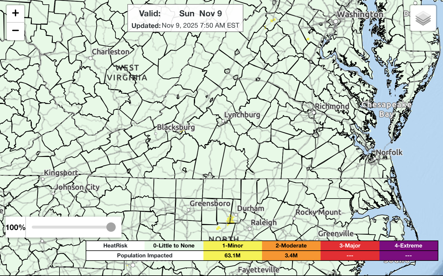
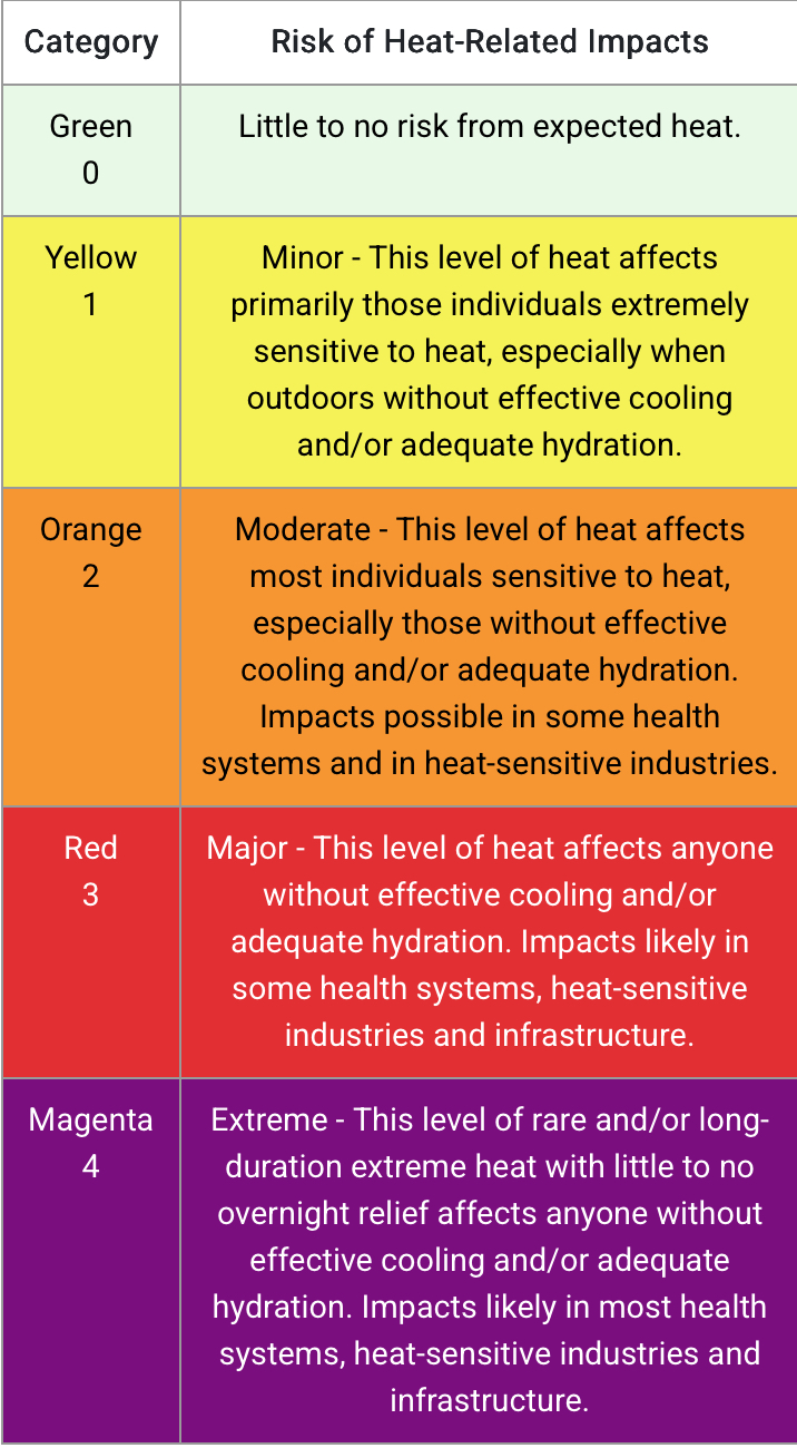
National Weather Service Heat Index, Sunday, November 9.
Weather From the 17th Tee
I am a retired Navy atmospheric boundary layer and radar meteorologist. A boundary layer meteorologist studies the lowest layer of the atmosphere where humans live and conditions are related to the characteristics of the surface. A radar meteorologist interprets the returns from a radar transmitter to quantify the existence of rain, snow, hurricanes and tornados. My professional life was entirely about solving customer’s problems using the scientific method. The purpose of this site is to provide my neighbors in the Wilderness of Spotsylvania with actionable weather and climate information that may impact their lives.
Rob Marshall, BSEE, MSEE
PhD Atmospheric Science
New Posts
01/12/2026: I added the Climate Prediction Center seasonal forecast for January-March.
01/10/2026: I added the Climate Prediction Center forecast for January .
11/28/2025: I added the current Virginia Drought Monitor. The Wilderness remains in severe drought.
09/05/2025: I added the current drought monitor for VA It appears drought is creeping back into VA.
08/03/2025: I added the Climate Prediction enter forecast for August-October.
06/22/2025: I added the National Weather Service Heat Index map. It will be updated every morning.
06/11/2025: I added climate change predictions for extreme fire days in the Wilderness in the right column.
05/11/ 2025: I have added Climate Predictions for Rainfall and Water Deficits in the Wilderness to the climate prediction discussion.
05/09/2025: I have added a few comments about how we can protect ourselves from the coming high heat index forecasts for the Wilderness
05/01/2025: I have begun a discussion on the quantitative changes climate change will bring to the Wilderness. You will find it in the center column
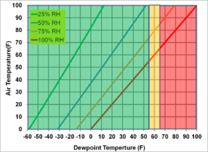
Dew Point and Relative Humidity
 Yellow is Uncomfortable. Red is Dangerous.
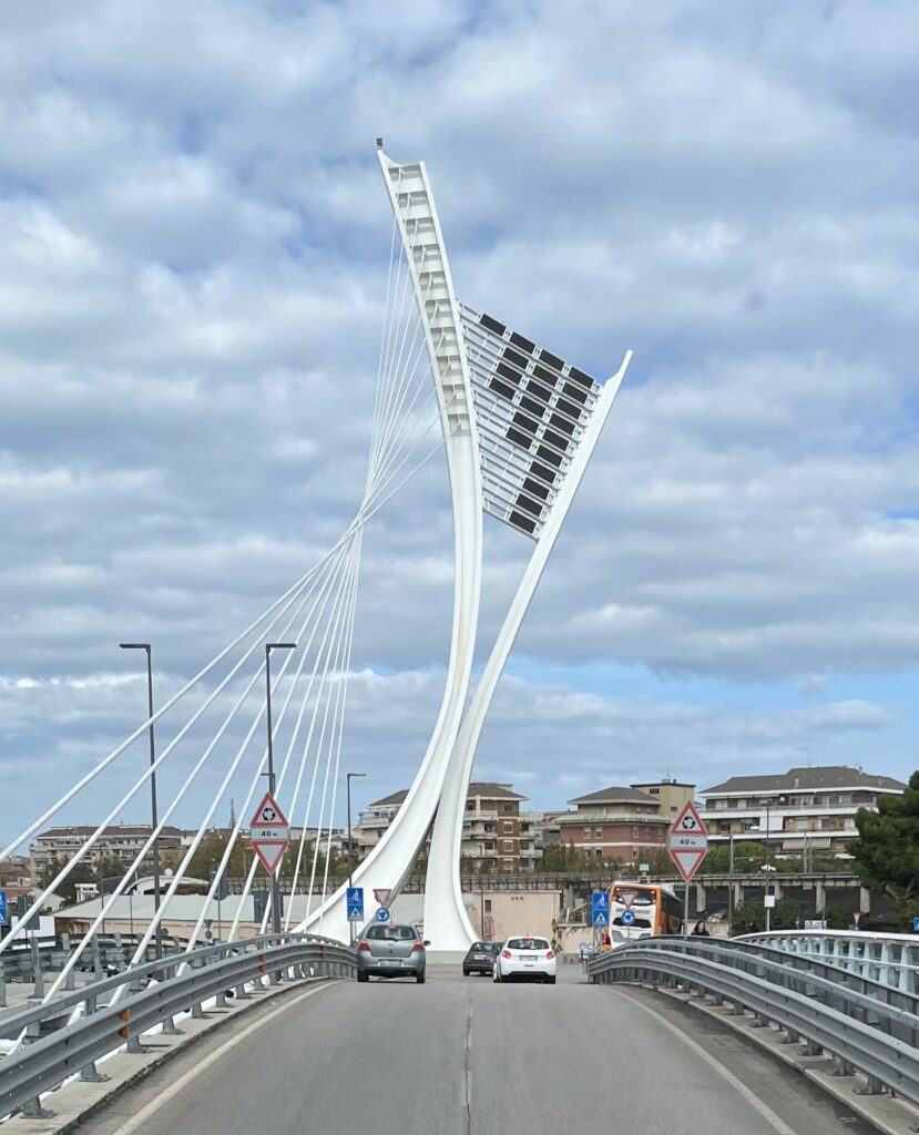
Ennio Flaiano Bridge in Pescara, Chiete, Italy
The National Oceanagraphic and Atmospheric Administration has Predicted a greater than normal Atlantic Hurricane Season
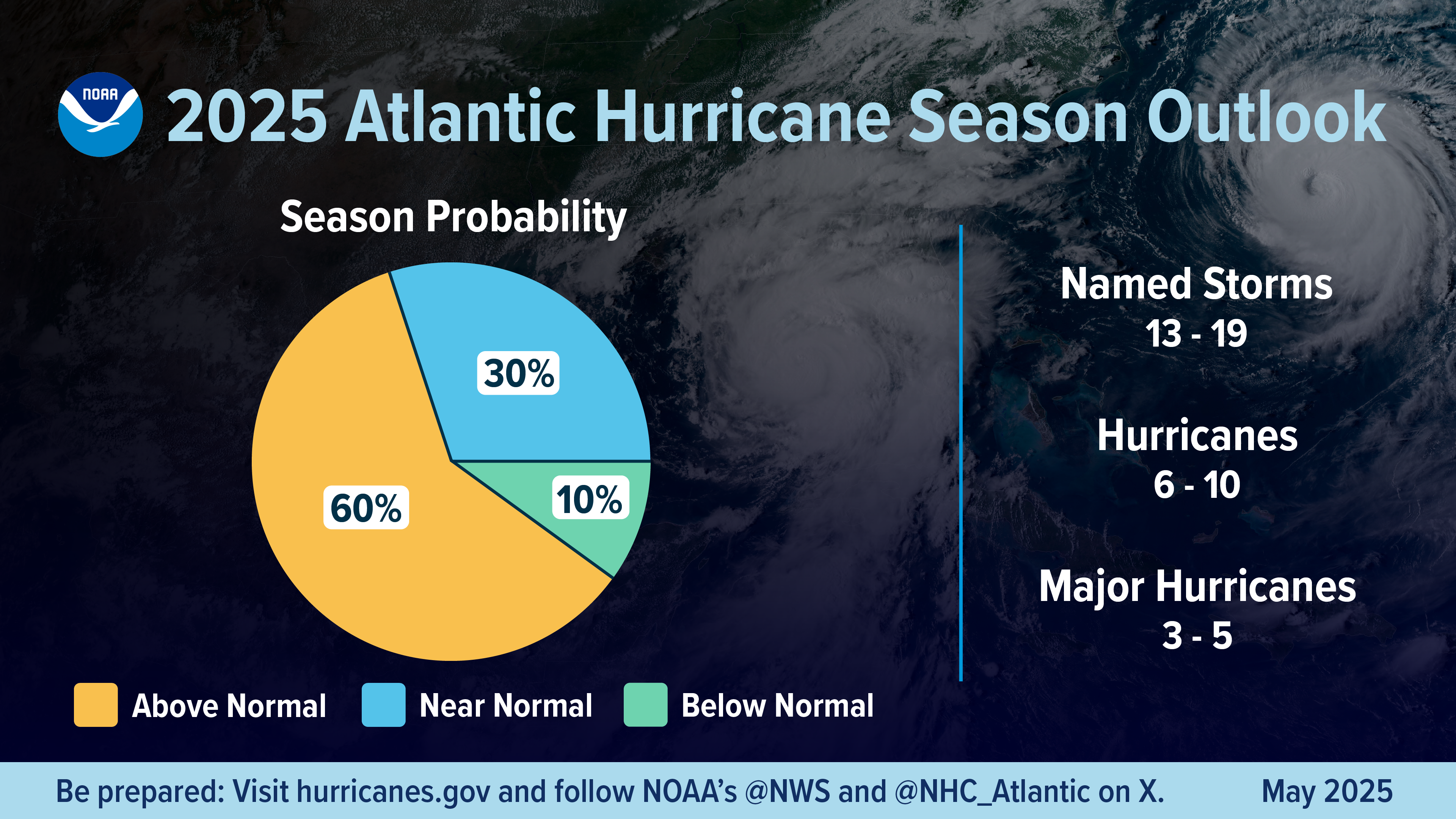
We have learned from the horrific impacts of Hurricane Helene last year in the Blue Ridge of NC and VA that flooding, tornado and high wind deaths are now possible in VA due to tropical storms.
Climate change is intensifying tropical storms, leading to stronger winds and heavier rainfall. Warmer ocean temperatures provide more energy for storms to develop and intensify, while a warmer atmosphere can hold more moisture, resulting in more intense rainfall.
We will need to pay closer attention to tropical storms approaching the Wilderness than we have in previous decades.
Tomorrow’s Weather
Tomorrow’s weather in the Wilderness, Wednesday, January 28. (Updated every morning by 8AM).
The ridge of high pressure stretching from Saskatchewan into TX will persist. Another reinforcing quiescent cold front will drop through WV during the day and then the Wilderness after sunset.
Winds will be light and variable becoming NW near sunset. Clouds will develop in the afternoon as the cold front approaches the Wilderness.
Temperatures will reach the high 20sF. Dew point temperatures will be near 10F.
Overnight temperatures will drop into the single digits F.
Climate Change Projections for the Wilderness
With the recent withdrawal by the United States from International climate negotiations it has become clear that CO2 emissions will continue to rise and so will worldwide temperatures. This is supported by the Environmental Protection Agency turning it's back on science this week by rescinding the scientific studies that prove greenhouse gases are contributing to climate change.
A country that turns its back on science will lose it's competitive edge and diminish it's ability to advance the welfare of citizens.
Over the last few weeks, I have consulted with international, national and Virginia climate experts to learn about climate prediction tools that allow me to predict what climate change will mean for the Wilderness. I will begin with temperature this week and continue on to other topics over the next few months.
Climate forecast models employ an ensemble approach. In the US, climate scientists run approximately 20 national and international climate prediction models leading to as many answers for variables such as temperature, humidity, rainfall, etc. Statistics are run on this ensemble of answers and the mean is projected as the forecast.
This ensemble approach has two forks. The first assumes that climate negotiations will be successful and CO2 emissions will remain at current levels. The second assumes climate negotiations will fail and CO2 emissions will continue to increase at the current rate. This is the so called "business as usual" solution or "worst case scenario"
It appears that our politicians have decided to reward us with the worst case climate prediction scenario.
Temperature Projections for the Wilderness
In the 1990s, the average summertime high temperature in the Wilderness was 86.7F. The highest temperature recorded was 98.6F. There were 11 days when the heat index reached 100F.
In the middle of the current decade, the average summertime high temperature will be 89.6F with a high temperature of 101.8F. There will be 27 days when the heat index reaches 100F.
By 2030, the average summertime high temperature will be 91.0F with a high temperature of 102.5F. There will be 31 days when the heat index reaches 100F.
By mid century, the average summertime high temperature will be 93.0F with a high temperature of 105.5F. There will be 52 days when the heat index reaches 100F.
The heat index takes into account the amount of water vapor in the atmosphere and is an indicator of the danger to your health during outdoor activities. Extreme heat indices are a leading cause of weather related deaths in the US. Agricultural and landscaping workers will be vulnerable during these predicted high heat index periods.
One positive aspect of climate change for the Wilderness is the growing season. In the 1990s, the last average frost date was April 7 and the first average frost date was October 24.
During the current decade, the last frost date is April 1 and the first frost date is November 1.
By 2030, the last frost date will be March 31 and the first frost date will be November 3.
By mid century, the last frost date will be March 26 and the first frost date will be November 11.
There are a number of climate websites that are proposing how to defend your home against the approaching heat stress crescendo.
These include added wall and attic insulation, southern exposure shading in windows, weather stripping in Windows and doors and trees that protect your home from late afternoon sun.
With regards to your personal health, you will need to pay attention to heat index forecasts. If you are young you can work through a high heat index day by hydrating during your outdoor activities. If you are old like me, just stay inside and read a good book during the ever increasing high heat index days.
Boundary Layer Meteorology
Over land the atmospheric boundary layer is diurnal that is a fancy term for changes with the rotation of the earth. Just like you, the atmospheric boundary sleeps at night without the sun heating the earth. As the sun rises, it heats the earth similar to heating a pot of water on the stove and creates vertical fluxes of temperature and moisture rising into the atmosphere. By way of turbulent eddies reaching towards higher elevations, winds at higher elevations are brought down to the surface in a mathematical and physics term called momentum flux. As the sun sets, this sun driven turbulence dies and the layer you live in returns to sleep. I wake every morning an hour before the sun rises to watch this transition. Yes, weather geeks are strange. During this time my attention and writing will be focused on the day ahead in terms of weather that might impact your day.
My objective as I develop this page is to learn about what weather information is important to your life.
Feel free to contact me with any questions or suggestions for topics you would like me to address.
January 2026 Climate Prediction Center Forecast
![]()
TEMPERATURE
The normal maximum temperature for the Wilderness in January is 43F. The normal minimum temperature for the Wilderness in January is 25F. There is a slight 39% chance that temperatures will be below normal in the Wilderness in January.
Precipitation
The normal precipitation for the Wilderness in January is 3.00 inches.
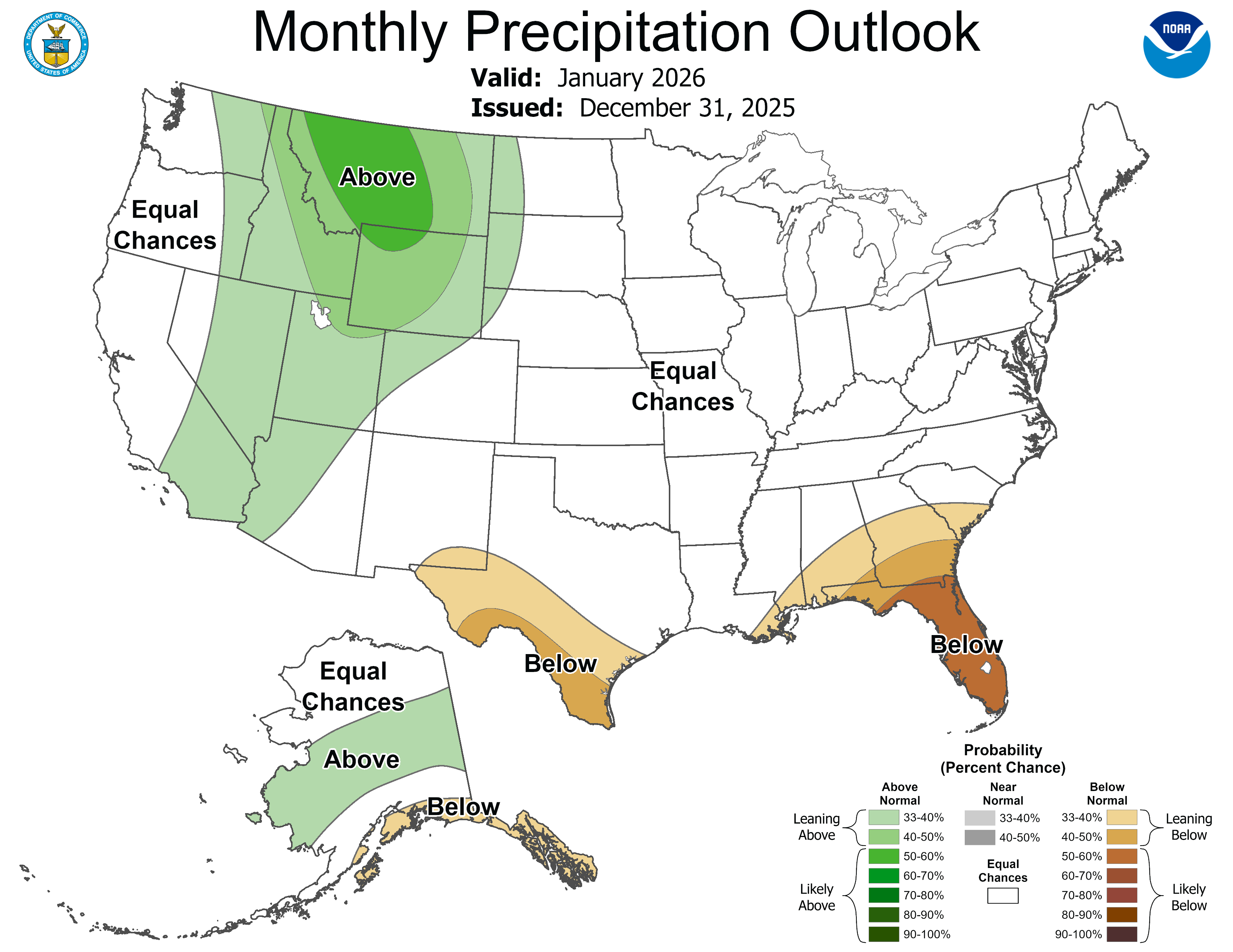
There is no indication that precipitation in the Wilderness in January will be abnormal.
Normal is a 30 year average.
My Assistant
Maximum Water Vapor and Temperature
The amount of water vapor (water in the gaseous form) that the atmosphere can hold before condensation (saturation) and ensuing precipitation increases with increasing temperature. This is shown in the graph below.
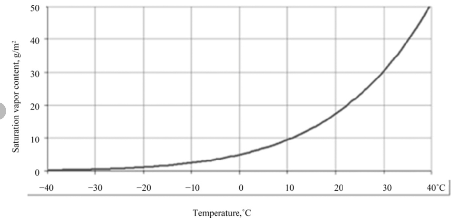
Water vapor on the vertical axis is in volumetric units of grams per cubic meter. Temperature on the horizontal axis is in degrees Centigrade.
Notice that at 20C (68F) the curve becomes strongly non linear and saturation water vapor increases rapidly with temperature.
This is why a 1 to 2 degree C increase in atmospheric temperature due to climate change can lead to a disproportionate amount of water vapor in the atmosphere leading to heavier precipitation events.
Weather Next Weekend
Weather in the Wilderness, January 31 - February 1. (Updated by 5PM)
As of Tuesday afternoon, the US and European weather models encourage the possibility of a coastal winter storm impacting the Wilderness next weekend.
As we saw yesterday, both the US and European weather models predict the jet stream will drop into the Gulf Coast states next weekend supporting high temperatures in the Wilderness in the mid 20sF.
Additionally, both models believe low pressure will develop somewhere near the FL/GA coast and move up the mid Atlantic coast developing into a nor’easter.
But model differences remain that do not allow us to be specific about what winter weather we will experience in the Wilderness.
The European weather model wants the developing strong low pressure off the SC/NC border Saturday morning to move quickly out to sea without producing a single snowflake in the Wilderness.
The US weather model in stark contrast thinks the low pressure will slowly move up near the NC and then the VA coast Saturday and Sunday leading to a significant snow event in central VA including the Wilderness.
Such a wide disparity amongst weather models makes it clear that as of Tuesday afternoon we do not know, other than it will be cold, what our winter weather will be in the Wilderness next weekend.
Stay tuned.
Climate Predictions for Rainfall and Water Deficits in the Wilderness
Climate models predict a counter intuitive future for rain and water deficit for the Wilderness as we move into the mid century and beyond.
A water deficit refers to a situation where the demand for water for our grass, gardens, forests and pastures exceeds the available supply from rain. The process is known as evapotranspiration or the process by which water is transferred from the land to the atmosphere by evaporation from the soil and other surfaces and by transpiration from plants.
In the 1990s, the Wilderness typically received 43 inches of rain. The rain deficit was positive at +0.6 inches or a surplus.
During the current decade the normal annual rainfall is 44.8 inches while the water deficit is -1.2 inches. No wonder our golf course workers struggle to keep the 17th tee green in the summer.
By 2030, the annual rainfall in the Wilderness will normally be 45.5 inches while the water deficit will be -1.65 inches.
By mid century, the annual rainfall in the Wilderness will typically be 45.9 inches. The water deficit is predicted to be an astounding -3.9 inches.
It will become increasingly difficult and expensive to maintain our current grasses, perennials, shrubs and trees. Our local farmers will struggle to maintain crops and pastures. What will happen to the 17th tee?
Experts recommend that it is time to begin thinking about more drought tolerant grasses, shrubs, perennials and trees. They also suggest that you cut your grass on the highest mower setting. This will reduce evaporation from the soil and create deeper roots for your grass.
Extreme Fire Danger Predictions for the Wilderness
Extreme fire danger days are based on the amount of moisture in drying material, 1-3 inches in diameter.
In the Wilderness during the 1990s, there were typically 0.6 extreme fire danger days during the summer months. During the fall months there were 0.3 extreme fire danger days.
In the middle of the current decade there are 1.3 extreme fire danger days during the summer months and 0.4 days during the autumn months.
By 2030 there will be 1.5 extreme fire danger days during the summer months and 0.5 days during the autumn months.
By 2050, there will be 2.4 extreme fire danger days during the summer and 0.6 days during the autumn.
Not surprising, recommendations include removing all flammable yard waste from around your yard. Flammable hardwood mulch next to your home is a concern. Dead evergreen trees should be eliminated. Exterior faucets and hoses should be be distributed around your home such that water can reach the entire exterior of your home. Make an evacuation plan.
Water Vapor and Dew Point
High amounts of water vapor ( water in the gaseous state ) in the atmosphere prevents your body from cooling in high heat. Dew point temperature is a direct measurement of the amount of water vapor in the atmosphere next to your skin. The chart below delineates the relationship between water vapor in grams of water vapor per kilogram of atmosphere and dew point temperature in degrees Fahrenheit.
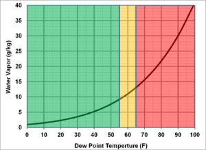
Yellow is Uncomfortable. Red is Dangerous.Hydration Required.
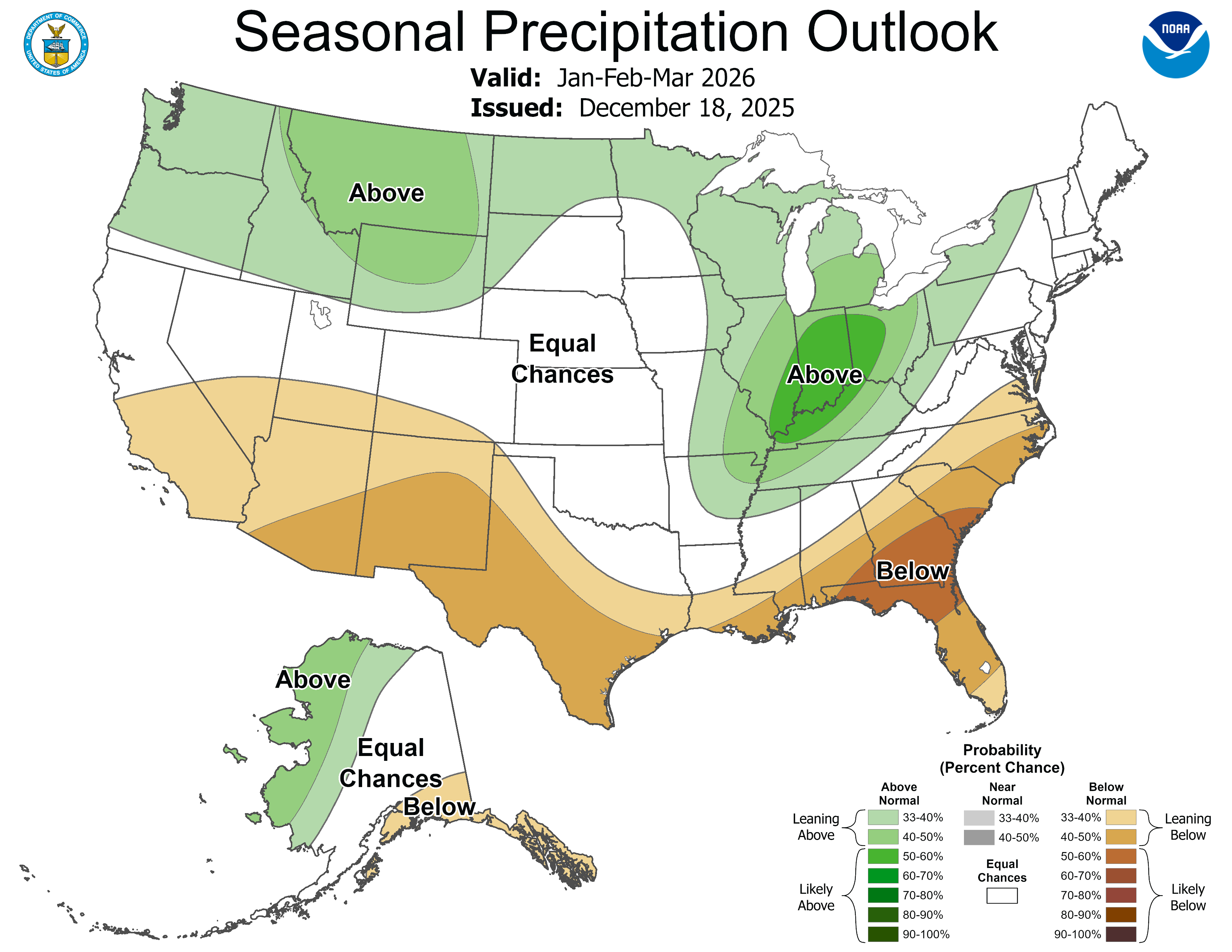
January-March, 2026 Climate Prediction Center Forecast
TEMPERATURE
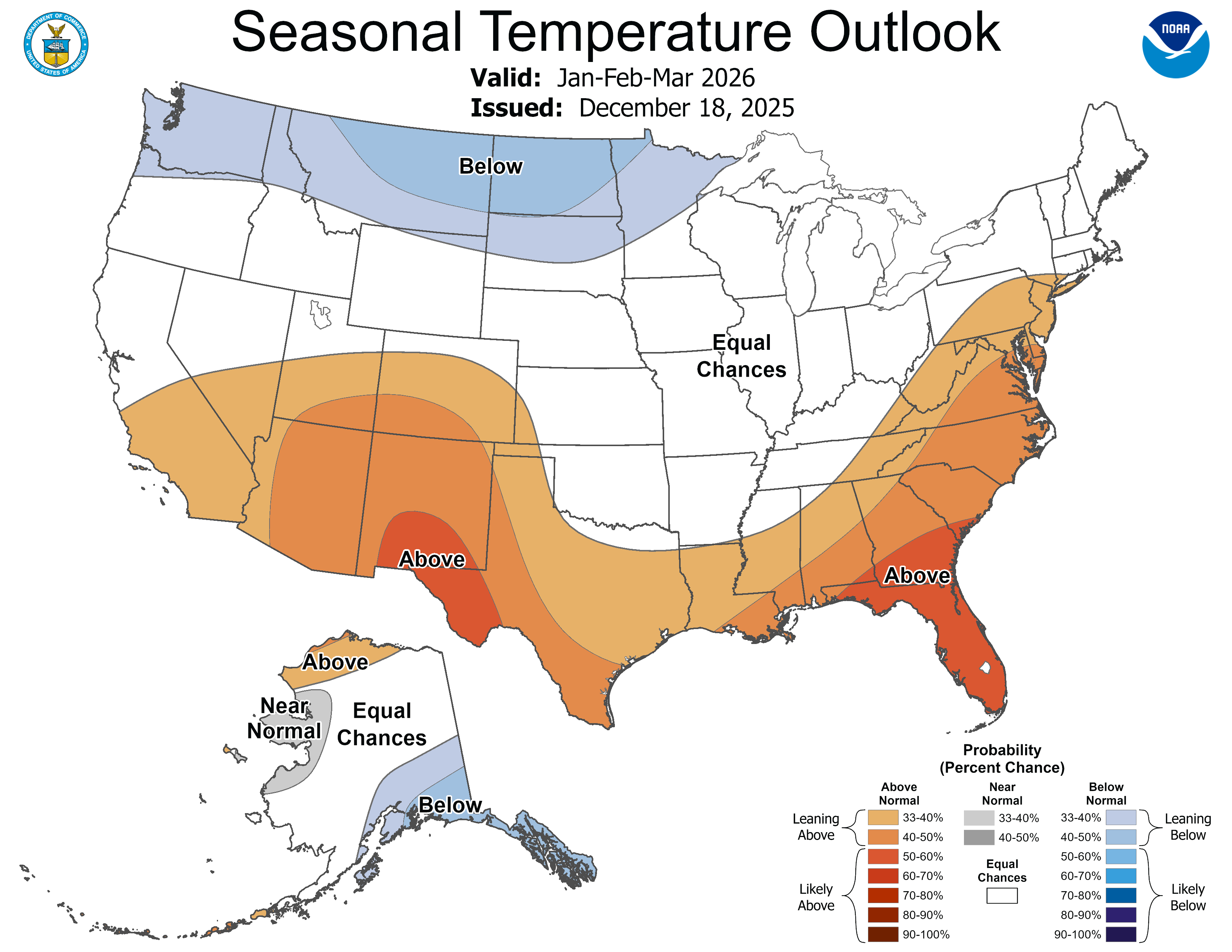
There is only a 41% chance of temperatures being above normal in the Wilderness, January-March.
PRECIPITATION
There is no indication that precipitation will be abnormal in the Wilderness, January-March.
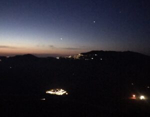
Sunrise in Celenza sul Trigno
Moonrise in Celenza sul Trigno

Gerard Mulot Chocalatier
76 Rue de Seine
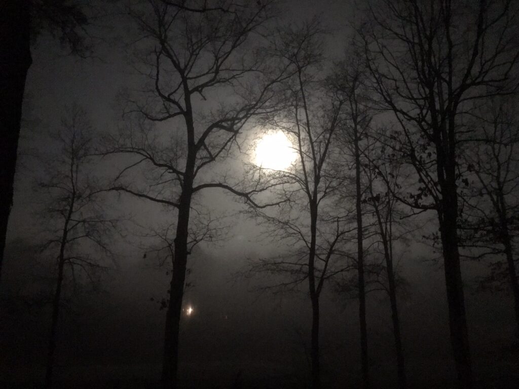
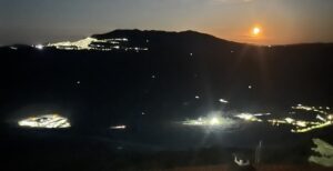
17th tee in the moonlight